


Indoor Mapping Technologies: solutions comparison and main market trends

Understanding Indoor Mapping and its growing adoption among public and private sectors worldwide
Have you ever found yourself rushing through a massive airport terminal, searching for Gate E47 when your smartphone's GPS signal has vanished the moment you stepped indoors? The overhead signage is confusing and finding someone to ask for directions to a point of interest (ex. available services, amenities...) costs precious time and it’s not always easy. This scenario plays out millions of times daily not only across airports, but also within hospitals, shopping malls, smart cities and corporate or university campuses worldwide. Here is a critical gap in our digitally connected world.
This is when indoor cartography comes into play as the technological solution to solve this indoor navigation challenge. At its core, indoor mapping is the process of creating digital representations - maps - of interior spaces that enable precise positioning, wayfinding and spatial analysis within infrastructures where traditional GPS signals cannot work at its best.
In fact, differently from outdoor systems that rely on satellite signals, indoor maps leverages alternative positioning technologies: from Bluetooth beacons to ultra-wideband sensors, combined with detailed floor plans to create interactive, navigable maps of indoor spaces.
To be effective, the indoor mapping is made of three essential components: digitized spatial data (the maps themselves), an indoor positioning system (IPS) to determine user location and an intuitive user interface to provide visitors with real-time navigation.
The market momentum behind indoor mapping is undeniable. Valued at $13.74 billion already in 2024, the global indoor location market is expected to reach $46.50 billion by 2030 - mainly driven by accelerating digital transformation across multiple industries (smart buildings, healthcare, transportation hubs) and growing demand for enhanced visitor experience.
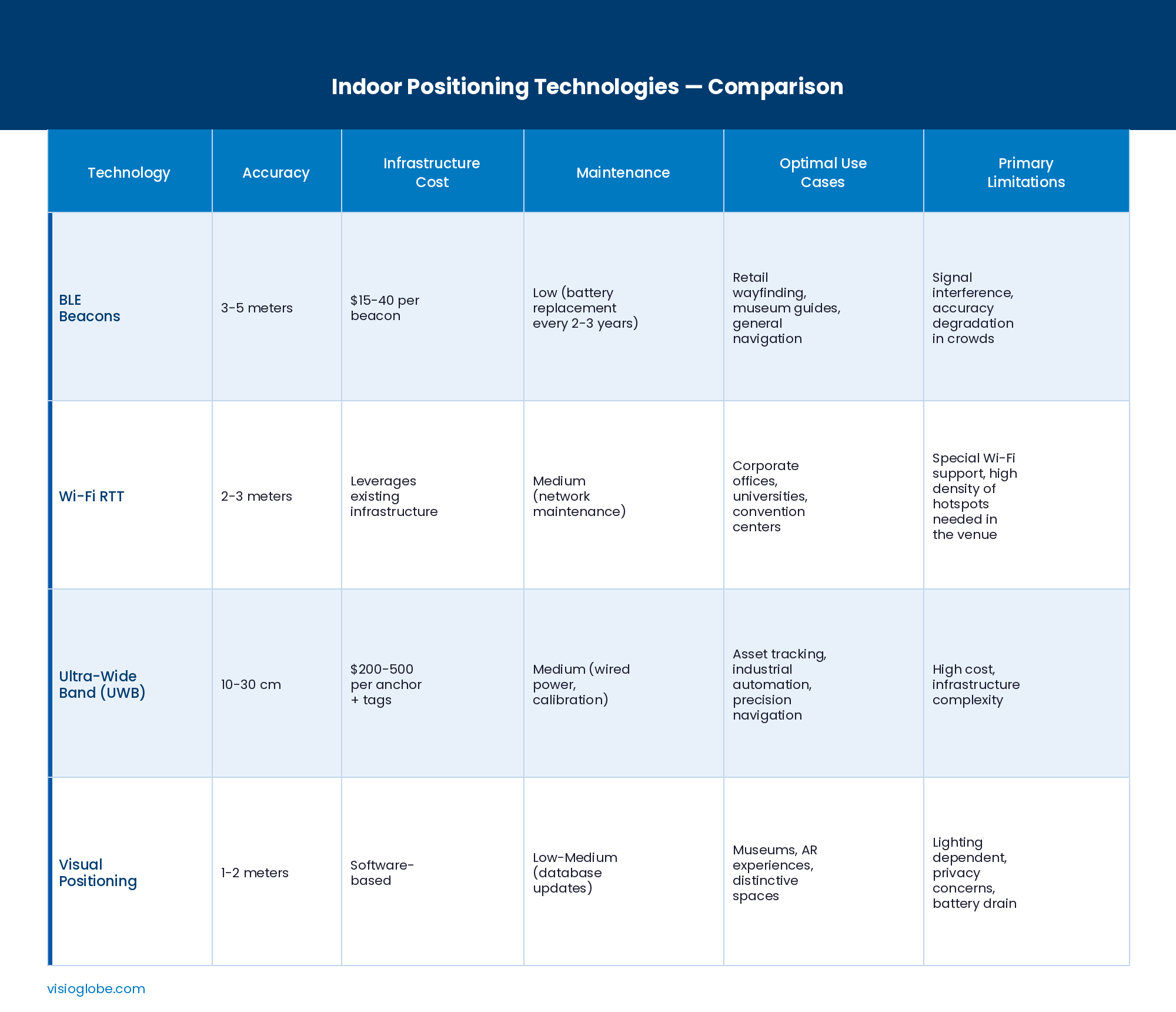
Indoor Mapping Technologies: a comprehensive tour and comparison about the most popular systems
Understanding the technological landscape around indoor mapping is fundamental when you are wondering what indoor positioning system would better work with your business specificities. In fact, each technology offers different advantages, limitations and optimal use cases that may align (or not) with your operational requirements and budget constraints. Here are the 4 most popular solution technologies:
1. Indoor positioning with Wi-Fi RTT and triangulation
Among the most popular solutions, Wi-Fi positioning leverages the existing wireless infrastructure, eliminating the need for dedicated hardware within indoor venues where Wi-Fi coverage is common and reliable.
Traditional Wi-Fi positioning relied on RSSI fingerprinting*, mapping signal strength patterns throughout a space and comparing real-time readings against this database. Despite being functional, this approach required extensive calibration and struggled with environmental changes. Today, Wi-Fi RTT (Round Trip Time)** fundamentally improved accuracy by measuring actual signal travel time rather than strength, achieving 2-3 meter precision without exhaustive fingerprinting.
The primary advantage of Wi-Fi positioning is leveraging the existing ecosystem: organizations already operating enterprise Wi-Fi networks can implement positioning capabilities with minimal additional costs and hardware investment. This is what makes Wi-Fi RTT exceptionally cost-effective for corporate office buildings, universities and campuses as well as for convention centers and other cultural venues, like museums, with established networks.
Some challenging factors to take into account include: access point density requirements, potential interference in congested frequency bands and the necessity of device compatibility - since not all smartphones support Wi-Fi RTT. Additionally, positioning accuracy depends heavily on network infrastructure quality and configuration.
*RSSI fingerprinting: Received Signal Strength Indication, it is a popular indoor localization method that maps an area by recording Wi-Fi signal strengths.
**RTT: Round Trip Time: the time for a Wi-Fi signal to travel from a device to an access point (AP) and back.
2. Indoor positioning with Bluetooth Low Energy (BLE) and beacon technology
Bluetooth Low Energy (BLE) has emerged as the most widely deployed indoor positioning technology, balancing reasonable accuracy with cost-effectiveness implementation. BLE beacons are small, battery-powered devices that regularly broadcast unique identifiers.
To provide an example: when a user launches a mall’s app on their smartphone, the bluetooth signals transmitted by the beacons within range are detected and interpreted by the mobile device to determine the user location.
BLE deployments generally achieve between 3-5 meter accuracy, which is sufficient for wayfinding purposes in retail stores, museums, trade shows, airports or even hospitals.
Implementation costs remain relatively low and the beacons’ battery life typically extends 2-3 years, minimizing maintenance operations. This technology's infrastructure-free nature represents another advantage: no cabling or network modifications are required and it is particularly interesting for equipping existing buildings and upgrading their connectivity as well as their overall efficiency.
As for the previous technology, here are some challenging factors to consider: signal strength may fluctuate because of physical obstacles (human bodies as well!) and potential environmental interference within the venue, sometimes causing positioning inconsistencies. This is why for indoor applications that require precision below 2 meters, such as warehouse or surgical equipment tracking, BLE beacons turn out to be insufficient.
3. Indoor positioning with Ultra-Wideband (UWB) technology for centimeter-level precision
Ultra-wideband technology represents the premium tier of indoor positioning, capable of delivering centimeter-level accuracy, up to 10-30 cm, through precise Time of Flight (ToF)* measurements. UWB transmits short-duration pulses that enable extremely precise distance calculations between transmitters and receivers.
Differently for the technologies mentioned above, this solution's exceptional accuracy comes from its resistance to multipath interference and capability of bypassing obstacles more effectively, facing up challenging environments.
Among the industries that apply UWB technology the most:
- Warehouses and manufacturing facilities are generally more likely to deploy them for precise use cases: real-time asset tracking, autonomous vehicle navigation and safety zone monitoring.
- Healthcare organizations typically rely on UWB to track high-value medical equipment and grant that critical assets stay both accessible and available.
- Retail operations may also implement UWB for advanced inventory management and loss prevention.
Despite its significant advantages, this technology comes with two major drawbacks: on the one hand the cost, which can sometimes be 5 times higher than BLE installations; on the other hand the deployment complexity, that requires precise hardware positioning and calibration to ensure best efficiency. These factors make UWB solutions economically viable primarily for the businesses’ applications where centimeter-level precision directly impacts operational efficiency and/or safety.
* Time of Flight (ToF): a calculation measurement based on how long a signal takes to travel to an object and back to source.
4. Indoor positioning with visual positioning and computer vision
Visual positioning systems (VPS) use smartphone cameras and computer vision algorithms to determine a user location by analyzing physical environment features. To effectively work this technology compares real-time camera images with a pre-mapped database of visual patterns. In other words, it is actually similar to how humans navigate by recognizing landmarks.
Visual positioning best functions in feature-rich environments, such as art galleries, museums, retail stores with unique visual displays, achieving meter-level accuracy. This technology can even provide smooth integration with augmented reality (AR) experiences, by overlaying digital information directly onto physical spaces through the camera view.
As for any solution above, VPS has some limitations that include: dependence on appropriate lighting, significant hardware and software requirements (for instance, more rapidly draining device batteries), privacy concerns related to continuous camera usage as well as functional challenges in visually repetitive venues like hospital corridors or large parking spaces lacking distinctive features.
Emerging Indoor Mapping technologies and hybrid approaches
The indoor mapping industry is also witnessing the rise of hybrid systems combining multiple positioning technologies. In fact, modern platforms dynamically select the best available positioning method based on current conditions: for instance, opting for UWB precision where the system is deployed and then going back to BLE beacons or Wi-Fi RTT in other areas, ensuring as smooth as possible transitions.
Introduced in 2024, the Bluetooth 6.0's Channel Sounding feature promises to bring UWB-like distance measurement capabilities to the BLE beacon infrastructure, potentially transforming the overall cost/accuracy ratio. Meanwhile, 5G positioning can already offer new possibilities for stronger indoor location, though deployment remains early-stage.
As you may guess, the optimal technology selection ultimately depends on your business-specific requirements: precision needs, environmental conditions, budget constraints, existing infrastructure and use case priorities. Rather than seeking a universal "best" solution, successful implementations align technology capabilities with operational objectives and wayfinding, user experience goals.
Technical challenges & expert tips: what to expect when implementing Indoor Mapping
It is no mystery that interactive indoor mapping brings significant benefits to your business. However, implementations generally require further consideration to overcome some technical challenges along the way. Hereunder the most common ones.
- Indoors precision within complex environments
Buildings create challenging environments where indoor signal precision can be more affected by walls and metal structures than typical outdoor GPS capabilities. Technically speaking, signals reflect off surfaces and create “echo effects” that confuse indoor positioning systems. Even human bodies partially interfere with signal accuracy: during very crowded periods, indoor positioning precision can sharply drop from 3 to 8-10 meters.
💡 EXPERT ADVICE: As a consequence, to ensure indoor precision and reliability, it is recommended to prepare for “the worst-case scenario” (being high traffic peaks) when planning to deploy indoor mapping within your venue: set realistic users expectations about the positioning accuracy and do not under-install adequate infrastructure (it could cost you more money later on!). Also, take into account hybrid approaches combining multiple technologies to meet both your constraints (i.e. budget, time) and your user’ evolving needs at different touch points within a complex environment.
- Integrating Indoor Mapping with existing systems and tools
Indoor mapping rarely operates alone. The most effective implementations seamlessly integrate with the existing ecosystem and tools, such as: building management systems, security infrastructure, content management platforms and analytics tools.
The real value of an indoor mapping solution lies in connecting with multiple third-party systems, collecting and displaying key data both on the users side, through indoor maps, and on the company side with a dedicated back-office platform.
💡 EXPERT ADVICE: When opting for an interactive indoor mapping provider, prioritize vendors with flexible third-party technology compatibility and well-documented APIs. Also, rely on integration specialists and allow up to 2-3 months for advanced integrations beyond the basic solution deployment, for effective, 100% customized delivery.
- Indoor Mapping and Privacy & Data Protection requirements
Indoor positioning intrinsically tracks user movements within a building, which requires careful handling to respect individual privacy as well as to comply with regulatory frameworks: for instance, GDPR (General Data Protection Regulation) in Europe and HIPAA (Health Insurance Portability and Accountability Act) in the US - and especially in healthcare settings.
💡EXPERT ADVICE: To get the most out of data while meeting privacy requirements, your organization should minimize comprehensive data collection by tracking exclusively what is genuinely necessary for the use case(s) to serve. Anonymizing data whenever possible is also a recommended best practice, particularly for analytical purposes where individual identification is not useful. Extremely important is also the opt-out option: users should be empowered to easily access navigation features without being tracked. In doing so, organizations that proactively address privacy policies and disclose their data practices tend to foster users’ trust and better engagement with indoor mapping systems.
Conclusion and future perspectives: where Indoor Mapping is heading
Indoor mapping is standing more than ever at the convergence of mobile computing, IoT, AI and innovations that are rapidly generating new ways of better navigating and interacting with indoor environments.
Among the most compelling transitions, the smooth disappearance of boundaries between outdoor and indoor positioning locations. In other words, technologies are getting smarter and more accurate to ensure seamless transitions and continuous wayfinding as people move from outdoor streets into smart buildings and back outside. This coverage is particularly valuable in today's dense urban environments, such as connected campuses and emerging smart cities around the world.
This seamless digital experience extends into how we, as users, actually experience the surrounding environment and navigation information. Big spatial computing companies like Apple and Meta are showing the way: guidance is moved off smartphone screens into people's field of vision, through Augmented Reality (AR) overlays. An innovative approach that unlocks new, immersive wayfinding experiences.
Underlying these innovations, there are also market initiatives to progressively break-down proprietary barriers (aka the vendor lock-in) and enable true interoperability across multiple platforms. The result: the creation of comprehensive smart building ecosystems where wayfinding integrates naturally with third-party existing tools such as energy management, analytics, maintenance operations and building automation software. These kind of integrations are already proving their value, delivering measurable impact on sustainability, amongst others. For example, large organizations leveraging precise occupancy data are right-sizing real estate portfolios and implementing smart climate controls that reduce energy consumption by 20-30%; similarly, optimized routing minimizes unnecessary movement across large warehouses, hospitals and retail spaces, cutting both operational costs and carbon footprints.
In the end, it becomes clearer than ever that interactive indoor mapping is no longer a specialized tool functioning alone. Rather, it's playing a key role in an essential infrastructure that reshapes and supports how we navigate, discover, experience and even enhance indoor spaces around us.