Indoor Maps for airports

Skyrocket your Airport operational efficiency

Help passengers reduce stress, save time and reinforce safety and security protocols.
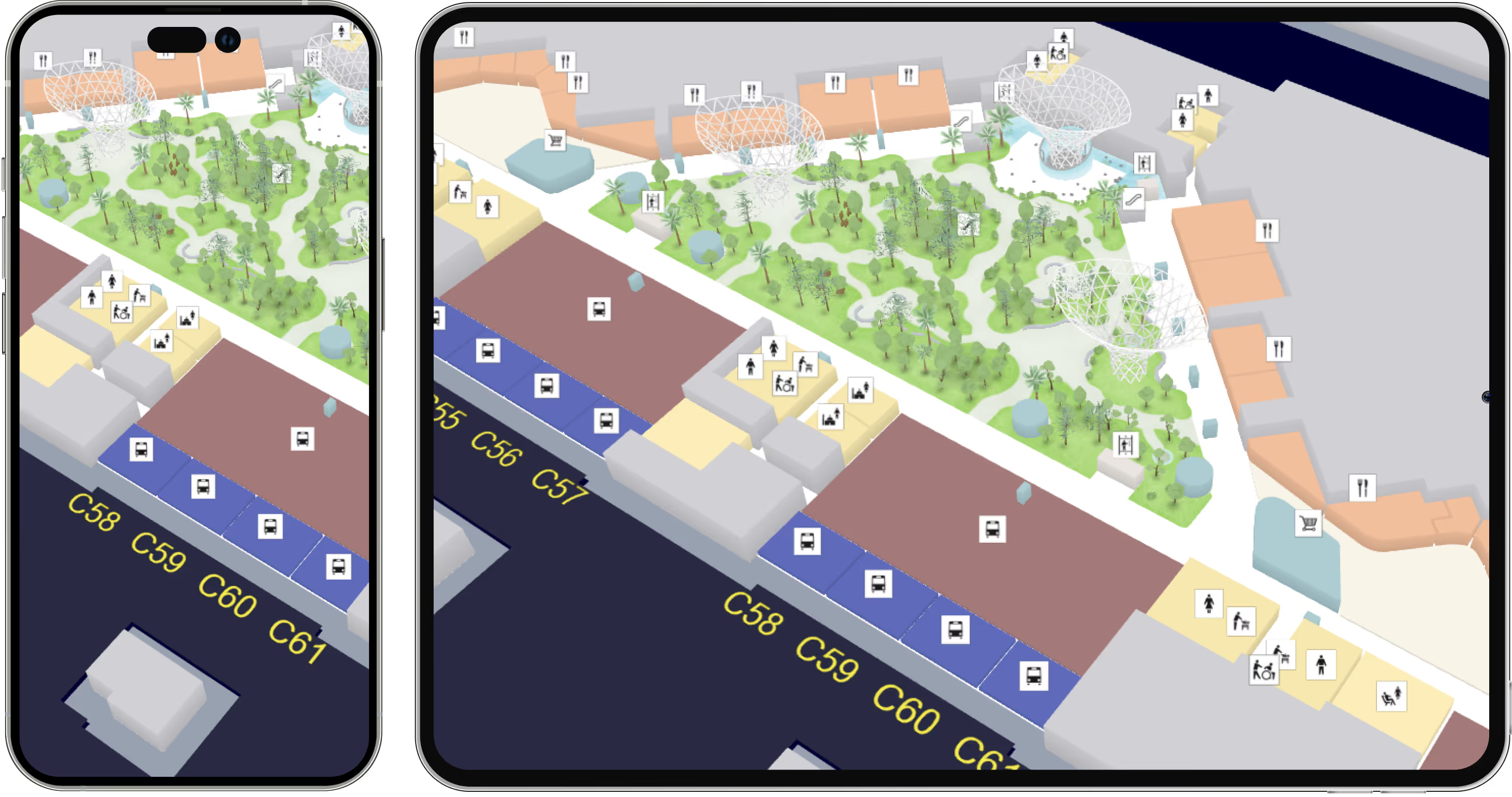
Building a relation of trust
with our partners & clients
.

Logo HIALogo Dubai AirportLogo Geneve AirportLogo LGALogo Malaysia AirportLogo HIALogo Dubai AirportLogo Geneve AirportLogo LGALogo Malaysia AirportLogo HIALogo Duabia AirportLogo Geneve AirportLogo LGALogo Malaysia AirportLogo HIALogo Geneve AirportLogo LGALogo Malaysia Airport

A robust indoor mapping solution can significantly enhance all passengers' life within airports by:

Ensuring timely departures

Show the quickest and most adapted routing to reach the destination point, taking into account any accessibility needs. Help passengers reduce time spent on searching for the right path, minimize the risk of getting lost or encountering delays and finally ensuring timely departures.

Reinforcing security and safety levels

Security personnel has access to accurate and up-to-date information about the indoor space through the map, which help promptly address incidents, preventing them from escalating and minimizing the risk for passengers. Plus, smart indoor maps provide clear directions to the nearest emergency exits and evacuation routes, in case of emergency.

Driving customer loyalty

Integrate with third-party digital platforms to create a cohesive and omnichannel travel experience. Get notifications about the best time to reach the right check-in area and even notifications from duty-free shops as well ad how to reach click-and-collect points.

See the power of Asset Tracking in airports

In airports the assets to keep under control are numerous: that can include baggage carts, ground support equipment, cargo containers, vehicle fleet as well as any tool, component and equipment for aircraft maintenance.

By integrating with third-party technologies, the right indoor wayfinding solution takes an active part in the process of monitoring and managing the location, the status and the movement of valuable assets within airports. And this, in real time.

Among the most common use cases to which asset tracking is a crucial resource:

  • Baggage Management: RFID tags or barcodes allow real-time tracking from check-in to claim. By providing accurate location data all along, the risk of misdirected or lost baggage is minimized.
  • Ground Support Equipment (GSE) Management: track the location and usage of equipment such as tugs, loaders, and refuelers as to optimize their deployment. Also, integrating IoT sensors help better monitor the condition of GSE and schedule maintenance proactively, reducing downtime.
  • Facility and Maintenance Management:  ensure that the facilities needed are readily available by tracking tools, parts, and equipment used in aircraft. This way, inventory is under control. To go further, analyze data from tracked assets to predict when maintenance is needed, reducing unexpected failures.

Additionally, this asset tracking use case can also be applied to other industries, such as hospitals and universities.

How to build stellar indoor maps for airports

This is our VisioMapEditor®: an all-in-one platform that provides all the necessary tools to design, publish and maintain marvelous airport maps. There are at least 7 must-have features to leverage:

An illustration of the import and export capabilities of our Map Editor
Import from multiple file formats and industry standards (.dwg, .pdf, images, GeoJson).Similarly, map exports can be made in multiple formats to suit your specific needs.
An illustration of VisioMapEditor's drawing features
Discover how easy and fun it is to create your own map, starting in a simpler 2D space. Use the basic geometric shapes and our design tools in Map Editor to make your ideal map for smart offices a reality.
an illustration of the 3D models capability of VisioMapEditor
Import from multiple file formats and industry standards (.dwEach map project comes with a full library of ready-to-use 3D models.
Let your creativity run wild and design unforgettable, amazing maps for smart offices and buildings.g, .pdf, images, GeoJson).Similarly, map exports can be made in multiple formats to suit your specific needs.
An illustration of VisioMapEditor routing  featurea
You may need to set different levels of access depending on profile types at some point.

Thanks to our profile access feature, you can manage information as you wish, giving specific users access to the information they need either in the back office (Map Editor side) or in the finished application.
An illustration of VisioMapEditor CMS featurea
Seamlessly integrate your maps into any existing or custom application by Add and manage information about your points of interests easily, by connecting your backend solution for Content Management to Visioglobe’s Map Editor.

No CMS? No problem! Our mapping tool backs you up, providing you with a simpler and efficient built-in solution.using our APIs and software development kits (SDKs).
Provide your collaborators with the best indoor navigation experience on multiple devices: kiosks, web, applications (iOS and Android)... you choose. Plus, publication times are lightning fast!
An illustration of the viewing capabilities of the VisioGlobe's solution
Seamlessly integrate your maps into any existing or custom application by using our APIs and software development kits (SDKs).
Provide your collaborators with the best indoor navigation experience on multiple devices: kiosks, web, applications (iOS and Android)... you choose. Plus, publication times are lightning fast!
An illustration of VisioMapEditor's profile feature
You may need to set different levels of access depending on profile types at some point.

Thanks to our profile access feature, you can manage information as you wish, giving specific users access to the information they need either in the back office (Map Editor side) or in the finished application.
An illustration of the import and export capabilities of our Map Editor
An illustration of VisioMapEditor's drawing features
an illustration of the 3D models capability of VisioMapEditor
An illustration of VisioMapEditor routing  featurea
An illustration of VisioMapEditor CMS featurea
An illustration of the viewing capabilities of the VisioGlobe's solution
An illustration of VisioMapEditor's profile feature

Case Study

Indoor map use cases office

Capacity: 30 million passengers a year

Number of check-in counters: 138

Passengers terminal: 600.000 m²

Total mapped area : 2 million m²

See the live app
Appstore Logo Button
Google Play store Logo

Presentation

Hamad International Airport is a state-of-the-art aviation hub in Doha, Qatar, known for its exceptional passenger experience and innovative design. It offers a wide range of amenities, including luxury lounges, high-end retail outlets, and gourmet dining options. With connectivity to over 160 destinations worldwide, it serves as a major global transit hub, making it a crucial gateway to Qatar and the Middle East region.

Map usage

Visioglobe indoor map is integrated in Hamad International Airport app to enhance navigation and wayfinding within terminals, providing passengers with a seamless and efficient travel experience.

Challenge and solution

Visioglobe's indoor mapping technology at Hamad International Airport has resulted in improved passenger guidance, better understanding of passenger flow, increased flight punctuality, higher traffic in duty-free areas, and real-time flight information. These advancements have significantly enhanced the overall travel experience at the airport.

See what our clients have to say

“Visioglobe is a long-standing partner who contributed to the success of our airport mobile application thanks to a mapping rich in features but without compromising on aesthetics and ergonomics of use. This service allows travelers to be guided from check-in to boarding while enjoying a visit to our stores according to their interests. The map will also be implemented on our website and will make it easy to locate the shops, services and restaurants at the airport. Visioglobe systematically questions itself in order to regularly offer us service improvements which are fundamental from an innovation point of view."

Logo Geneve airport
Building a relation of trust with our partners.

Take your applications to the next level with our mapping tools

Get a demo