Indoor Maps for universities

Discover the potential of Indoor Mapping for universities

Provide visitors, students and staff with a 100% accessible navigation experience, boost space efficiency and reinforce security

logo ready educationCitycon logo above the text ISO OMENA on a white background.A map layout of a shopping area featuring large IKEA and Carrefour stores, with smaller retail units including H&M, Intersport, and Maisons du Monde, parking areas, and surrounding roads labeled A64 and Rte des Estuaires.logo ready educationCitycon logo above the text ISO OMENA on a white background.A map layout of a shopping area featuring large IKEA and Carrefour stores, with smaller retail units including H&M, Intersport, and Maisons du Monde, parking areas, and surrounding roads labeled A64 and Rte des Estuaires.logo ready educationCitycon logo above the text ISO OMENA on a white background.A map layout of a shopping area featuring large IKEA and Carrefour stores, with smaller retail units including H&M, Intersport, and Maisons du Monde, parking areas, and surrounding roads labeled A64 and Rte des Estuaires.logo ready educationCitycon logo above the text ISO OMENA on a white background.A map layout of a shopping area featuring large IKEA and Carrefour stores, with smaller retail units including H&M, Intersport, and Maisons du Monde, parking areas, and surrounding roads labeled A64 and Rte des Estuaires.logo ready educationCitycon logo above the text ISO OMENA on a white background.A map layout of a shopping area featuring large IKEA and Carrefour stores, with smaller retail units including H&M, Intersport, and Maisons du Monde, parking areas, and surrounding roads labeled A64 and Rte des Estuaires.
How to build your map

The all-in-one solution features for exceptional university maps

VisioMapEditor® offers a comprehensive platform to create marvelous and effective indoor maps for your universities and campuses. Carry out your indoor mapping projects with our Map Editor and benefit from state-of-the-art features. Check them out:

An illustration of the import and export capabilities of our Map Editor
An illustration of VisioMapEditor's drawing features
an illustration of the 3D models capability of VisioMapEditor
An illustration of VisioMapEditor routing  featurea
An illustration of VisioMapEditor CMS featurea
An illustration of the viewing capabilities of the VisioGlobe's solution
An illustration of VisioMapEditor's profile feature
Case study

Discover how our clients use Visioglobe in universities
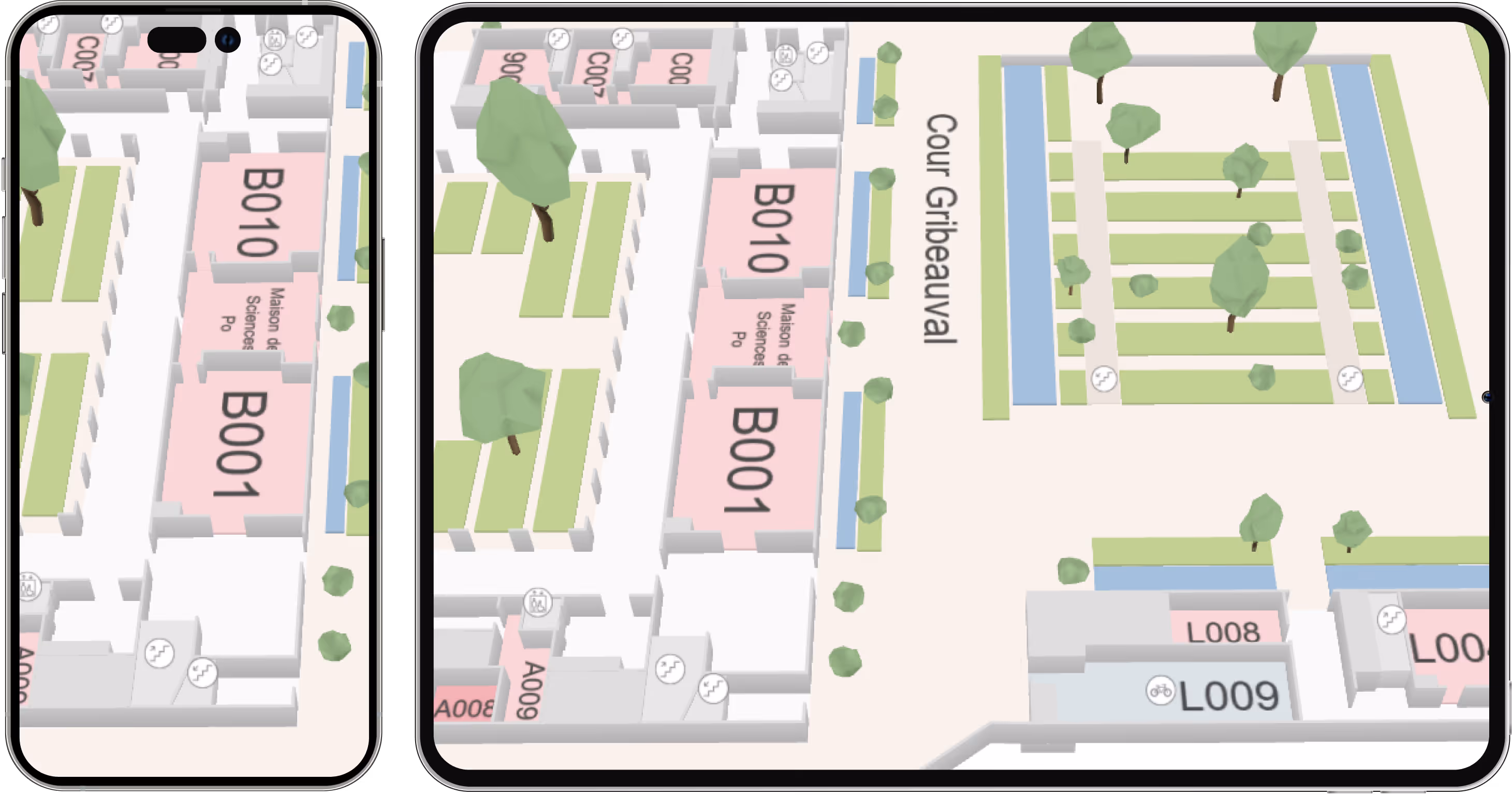
Indoor map use cases office

Presentation

The Institut Polytechnique de Paris, or IP Paris, is one of the most prestigious institution of higher education and research that brings together five major French engineering schools.

Map usage

With the Visioglobe’s map embedded in their app, IP Paris helps their students, staff, and visitors to easily locate classrooms, offices, lecture halls, and other facilities, saving time and reducing confusion.

Challenge and solution

Multiple typologies of users are accessing the application, making it essential to provide each type of user with an optimized experience. . In collaboration with our partner, Ready Education, we ensured that the map and the app were tailored to the client's specific needs.This strong partnership allows us to deliver a comprehensive solution that meets the client's expectations and fosters a positive experience for all users.

Logo IP Paris

Project Information

Students : 8500
Teacher and researchers : 1000
Total area : 275 873 m²

See the live app

Appstore Logo Button
Google Play store Logo
testimonial

See what our clients have to say

“Visioglobe and Ready Education partnership aims to create unique digital experiences for campus through easy-to-use and powerful indoor mapping technology.

Get in touch with an expert

Take your application to the next level